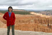
Bryce Canyon is like a different world on earth. Erosion forms
an array of fantastic shapes we know as "hoodoos".
Compared with the nearby national parks like Zion and Grand Canyon, Bryce
Canyon has its own splendor and extraordinary sights: Columns,
temples, castles, arches, bridges, windows, all are highlighted
by the vivid colors typical of southern Utah.
Getting there ...
We had a flight to Las Vegas at about noon. It's about 2.5
hours driving to Zion, and another 1.5 hours to Bryce Canyon. It
was a smooth and easy driving that we all considered it's a
"short" distance drive with only one stop of rest
before entering Zion.
The First Day ...
- Sunset Point
After checked in Bryce Canyon Lodge, we drove to Sunset
Point for sunset. We did not stay outdoors too long since
it was cloudy and getting cold, and there was no sight of
any sunset color. We headed back to have a warm dinner at
the Lodge restaurant. When we walked out the restaurant
after dinner, we were surprised that it began to snow
pretty hard!
The Second Day ...
- Sunrise
I drove to Sunrise Point and there was snow covering all
over the places. Initially the sun was hidden from the
cloud and I was a little disappointed. Suddenly, the sun
began to break out and shed the light to the hoodoos
under me. There were about 10 people at the view point,
but none of us spoke a single word. After a few shot at
Sunrise Point, I rushed to Sunset Point (with a wrong
turn and delayed for a minute). The light was still good
there for another 5 minutes before the sun disappeared in
the cloud again.
- Rim Drive
Following the plateau rim for much of its 18 miles, the
park road and its overlooks offer stunning geological
panoramas.
- Rainbow Point
Rainbow point is at the southern tip of the rim
drive. It is also the highest point along the
road with elevation of 9115 feet. We planned to
take the Bristlecone Loop Trail, but the trail
was covered by snow and was not passable at all.
- Bryce Point and Inspiration Point
 |
When we drove to Bryce
Point, the weather was cleared up and
temperature rose back to above 40F. After
a quick lunch in the Bryce Point parking
lot, we walked to the view point and we
were all stunned by the view. Bryce Point
is one of the most scenic vistas of the
full Bryce Amphitheater. When I stood by
the rim, my first impression was that I
don't have to stop at any other view
points any more. |
- Navajo Trail -- Queens Garden Trail
When I first got to the Sunrise Point before dawn, the
trail was still very icy. Now after a half day of sun
shine, it was already free of ice. We descent from Sunset
Point via Navajo Loop Trail, and ascent via Queens Garden
Trail to Sunrise Point. I think the Navajo Trail is a
must-go trail at Bryce Canyon. It descends and zig-zags
through the slot canyon of Wall Street, where a
450-year-old Douglas fir reaches upward toward the
sunlight at the top of the canyon. Linus and Iris were so
happy with the scenery of the trail that they didn't even
need too much rest on the way up on Queens Garden Trail.
After reaching Sunrise Point, Linus and I walked back to
Sunset Point via the 0.5-mile rim trail, and Woanyu and Iris
went to the general store to take a break. I think Linus is
already old and strong enough to take any trails I can (or
maybe even has more energy than I do...)
Going to Zion ...
After a short break at Bryce Canyon visitor center, we started
to drive to Zion to began our
2nd part of the trip.
[Back to Photo Page] [Go to Bryce Canyon Gallery]